|
“Mohammed made the people believe that he would call a mountain to him, and from the top of it offer up his prayers for the observers of his law. The people assembled: Mohammed called the mountain to come to him again and again: and when the mountain stood still, he was never a whit abashed, but said, ‘If the mountain will not come to Mohammed, Mohammed will go to the mountain.’ “ |
|
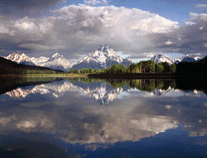
Much like Mohammed in his journey to the mountain, three million tourists a year head to Grand Teton National Park. They arrive from Montana to the North, Utah to the West, Colorado to the South and the Midwestern states to the east . Bumper to bumper, elbow to elbow they make their pilgrimage just to see America’s most famous mountain range. The majestic Teton Range, just 30 miles long, calls them forth from corners unknown. Little do they know, they are missing a hardly known scenic jewel, nestled just to the southeast of Wyomings most popular mountain range. |
Click on image for more information
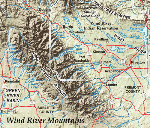
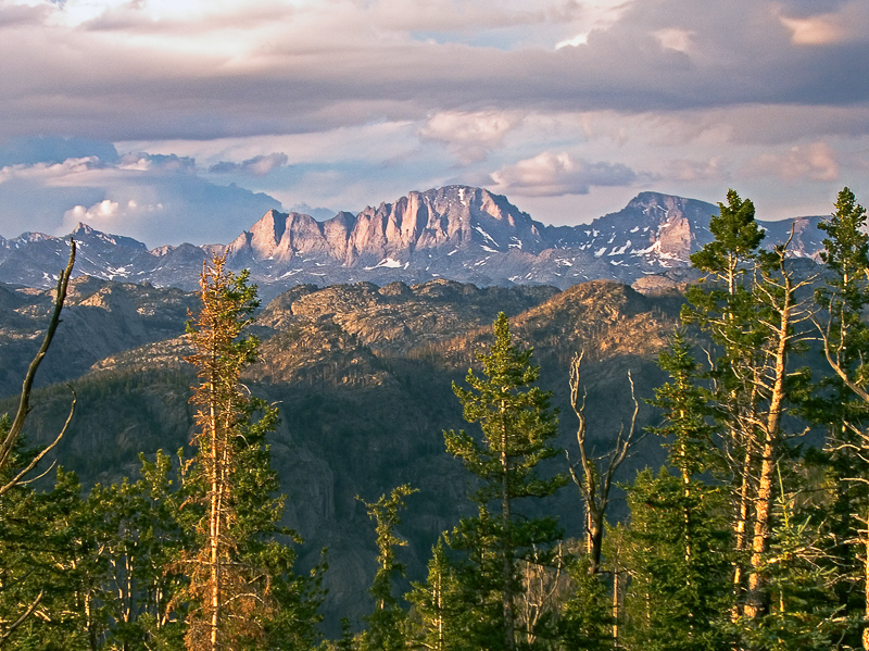
Located about 30 miles southeast of Grand Teton National Park, the Wind River Mountain Range runs roughly NW-SE for about 90 miles along the western part of the state of Wyoming. The Continental Divide follows the crest of the range and includes Gannett Peak, which at 13,804 feet (4,207 m), is the highest peak in Wyoming. It contains more than 40 other named peaks in excess of 13,000 feet. Of the twenty highest peaks in Wyoming, 19 lie in the Winds. Of those twenty highest, only Grand Teton, Wyoming’s second highest peak lies in the Teton Range.
Two large National Forests, the Shosone National Forest on the east side of the continental divide and the Bridger-Teton National Forest on the west side encompass most of the mountain range. Three large wilderness areas are located within these forests. This fact accounts for the low tourist traffic in the range. Only about 10% of the Wind River Range is accessible by car or 4WD. Most of the peaks and many scenic lakes are viewable only by a day hiker and many require a backpacking trip to access .
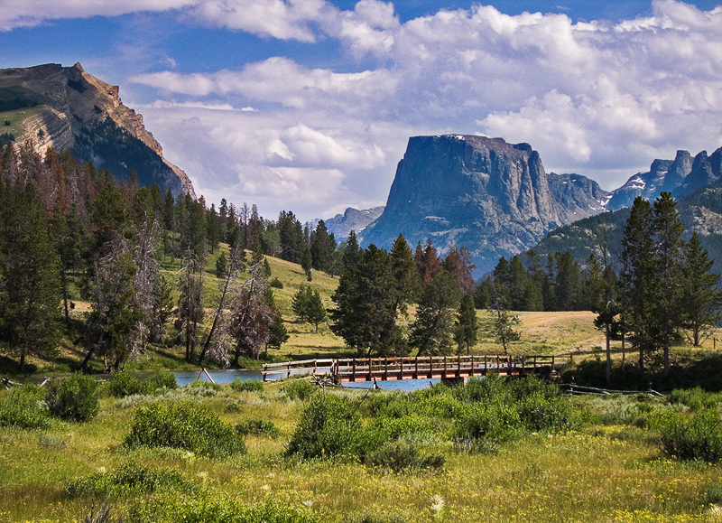
The most popular area in the Wind River Range is the Green River Lakes area. Accessible by car, the lakes are 52 miles north of Pinedale in the northern part of the Wind River Range. The lakes are considered the source of theGreen River, a major tributary of the great Colorado River system. Like many of the larger lakes on this side of the Winds, Green River Lakes were scoured out by glacial action, then sealed off by an end-moraine dam. An excellent camp ground is located at Lower Green River Lake and is great place to stay while exploring the area.
Photographics opportunities here include the lakes, much photgraphed Squaretop Mountain and various homesteader cabins. If your a fan of the West and cowboy life, one of the longest cattle drives in the nation, takes place when cowboys on horseback push livestock from the valleys to graze the rich mountain pastures, a distance of about 70 miles. Visitors on the road to Green River Lakes can observe this present-day historic phenomenon from the highway.
If you are a wildlife or nature photographer, expect to discover abundant mountain wildflowers and glimpses of wildlife such as antelope, moose, elk, deer, bear, hawks and eagles.
Click on image for more information

Click on image for more information
The other highly popular and easy to access area in the range is Fremont Lake. Only 3.2 miles from Pinedale, this stunningly beautiful and pristine lake provides several photographic opportunities. Surrounded by timbered foothills and a backdrop of spectacular snowy peaks, Fremont Lake is 12 miles long, half a mile wide, and 600 feet deep.
The Fremont Lake overlook can be spectacular when the Aspen are turning in early fall. A excellent example of glacial geology, the lake was gouged out by an ancient glacier and is dammed at the lower end by a terminal moraine.
Just past Fremont Lake overlook is Fremont Peak overlook. Fremont Peak on the continental divide and some 12 miles distant, glows beckoningly just before sunset in the late summer and early fall. Named for American explorer John C. Fremont who climbed the peak with Charles Preuss and Johnny Janisse on August 13 to August 15, 1842. At that time, Fremont Peak was mistakenly thought to be the highest mountain in the Rocky Mountains, although there are actually over 100 higher peaks in the range. At 13,745 ft it is the third highest peak in Wyoming, surpassed in altitude only by Gannett Peak and the Grand Teton.
If you are truly adventurous, and wish to plan your trip to the Wyoming mountain range that most visitors miss, check out this site atPinedale Online.
About Miles Hecker
Miles has been involved with photography for over forty years. He teaches digital photography at Casper College in Casper,Wyoming. His photos have won awards fromNatures Best magazine,Photo.net, The Luminous LandscapeandWyoming WIldlife . Miles’ photos have been published in American Vignette, Backpacker Magazine, Natures Best Images, Popular Photography, Wyoming Audubon, and Wyoming Wildlife. He is co-founder ofWyoFOTO LLC.
Geotagged Photolocation Index
June 2013
You May Also Enjoy...
Girl in Ruins Bangladesh
Please use your browser'sBACKbutton to return to the page that brought you here.
