


by QT Luong

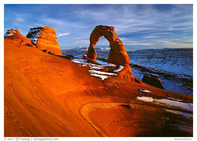
Delicate Arch, winter sunset
Canham KBC 5×7, Fuji Velvia, Schneider Super-Angulon 120mm, polarizer
Forty years ago, Arches was a little-known site with a single-track dirt road. It now attracts visitors from all over the world, many of them photographers drawn to its extraordinary rock formations. Although I have visited the park half-a-dozen times, turning a corner and finding myself in front of an arch remains a moment filled with wonder at the whimsy of nature.
Arches is a relatively compact park. An 18-mile scenic road with two spurs gives easy access to short to moderate trails leading to the arches the park is famous for. The longest trail in the park is a 7.2 miles loop. If going off-trail to look for new compositions, I always make sure to stay in sandy washes or on slickrock in order to avoid damaging the biological soil crust (cryptobiotic soil). Consisting of soil cyanobacteria, lichens and mosses, the fragile crust plays an important ecological role in the desert, and can take up to 45 years to recover from trampling.
When to go
You can visit the park year-round. Spring and fall are the most comfortable seasons, with the added benefits of wildflowers and (limited) fall foliage. Summer temperatures can reach into the 100s F, but the light might be the best, as thunderstorms bring dramatic skies in the afternoon and rains fill-up potholes. Winter temperatures can drop well below freezing, but there is a chance of a dusting of snow. In late fall and early spring, the La Sal mountains are snow-capped, providing a more spectacular backdrop that contrasts with the red rock.
Park Avenue & Courthouse Towers
Some of the largest cliffs and monoliths lie near the park entrance. While the light on Park Avenue is best around mid-morning and mid-afternoon, the more open location of formations such as the Organ and the Three Gossips mean that they are lit shortly after sunrise. Spring brings wildflowers to the area, while summer rains fill-up temporary potholes which can provide reflections.

Organ and Courthouse Towers, sunrise
Canon EOS 5D Mark III, EF100-400mm, polarizer, f/8.0 1/20 ISO 100
Courthouse Wash
In a desert park with no sources of water and little vegetation, Courthouse Wash provides the different experience of a refreshing desert oasis. I explored for most of an October day there, and didn’t see another person.
You are hiking in a canyon along a stream bordered by abundant riparian vegetation. Wading and stream crossing are necessary, so be sure to wear shoes that can get wet. Towards the end of October, willows and cottonwood trees turn bright yellow. Although there is no marked trail, it is difficult to get lost as you just follow the stream downstream (East towards Moab). The best way would be to use a vehicle shuttle so that you can hike 5.5 miles one-way, from the bridge over Courthouse Wash in the Park to Highway 191 0.3 miles past the bridge of the Colorado River, outside the Park. However, you can just retrace your steps, or just photograph the bright foliage from the area near the bridge over Courthouse Wash.

Bush and cottonwoods in autumn, Courthouse Wash, mid-day
Canon EOS 5D Mark II, Nikkor 14-24mm, f/11.0 f/125 ISO 100
Balanced Rock and Garden of Eden
The Balanced rock is a very obvious landmark near a major road intersection, yet I’ve found that to capture its wonder requires careful positioning. Not all angles reveal its stunning overhanging position. A short trail circles Balanced Rock, but views from there are too low and close, as foreshortening diminishes the size of the top balancing rock. I prefer to photograph from a further distance, across the road to the northwest. From there, the rock is bathed in a warm light at sunset, and silhouetted at sunrise. The Garden of Eden, on the way to the Windows, provides yet more whimsical spires.

Balanced Rock silhouetted against La Sal Mountains and sky, early morning
Canon EOS 5D Mark II, EF100-400mm, f11 1/30 ISO 100
Windows
Four impressive arches, North & South Windows, Turret Arch, and Double Arch, as well as many rock towers, are grouped in this small and popular area crisscrossed by a network of short trails. They offer a range of compositions and orientations from close, as well as a distant position with a super-telephoto lens, from as far as Balanced Rock.
In the early morning, you can try the classic composition of Turret Arch framed by North Window. Walk the main trail to the junction, and scramble carefully through North Window, and then left onto a small perch large enough for a couple of people to stand on. Further away, the backside of the Windows, a 1-mile primitive trail, is much quieter. From there, you can photograph the “Spectacles” (both North and South Windows cut from a single fin) with twisted and gnarled junipers as foreground. In the late afternoon, take the right fork from the junction to get on the western side of Turret Arch.
Standing in the alcove under the double span of Double Arch always fills me with awe, however I find the light difficult there. Mid to late morning may provide the most even illumination for daytime images, although I’ve been more successful here at night, when I can use my own lights.

Windows with view of Turret Arch from opening, early morning
Canham KBC 5×7, Fuji Velvia, Schneider Super-Angulon 90mm, polarizer
Delicate Arch
The trail to the signature landmark of the park is 3 miles RT long, all uphill, with 500 feet of elevation gain. It takes about 45 minutes to hike one way. The pleasant trail is marked by cairns and the wear left by generations of visitors on the slickrock. Although obvious by daylight, it requires much attention by dark, especially in winter, when the last hundred feet of the trail are often frozen. The light is best at sunset – although sunrise is much quieter and not bad at all. Since you may be descending after sundown, it is essential to bring a good light.
For this view, I much prefer winter. Since the Arch is south-facing, during the winter, it is entirely lit by the last light. The warm color of the sunset light enhances the natural color of the Arch, causing it to glow with a color that is almost surreal. In the summer, part of the Arch is in shadow at sunset, so you’d have to photograph it at least half-an-hour before sunset, when the light isn’t as great. Delicate Arch is a world-famous spot, so in summer prepare for crowds.
On the way to Delicate Arch, there are two sights worth noting. After you cross a suspension bridge over Salt Wash, turn left on a secondary trail along the dry bed and walk for about a hundred feet to a fork, and then turn right. You’ll see a panel of Ute petroglyphs. Near the summit, close to Delicate Arch, there is a small arch on your right that can be used to frame Delicate Arch.
On my second visit, during a frigid late November evening, other hikers took a quick look before heading back. As I stayed in the biting wind, the last light intensified the colors of the red Entrada sandstone rock, contrasting it with the blue colors of the snow-covered slope behind. By the time I returned to the parking lot, everybody had left. While the temperature had dropped to single digits, my car battery had died, but my expedition-grade sleeping bag kept me warm for the night. I was glad I was well-prepared for winter travel!
Looking for an alternative view, I tried the Upper Delicate Arch Viewpoint. The 1.3 miles RT trail leads to a view of Delicate Arch, which is quite distant, but shows well the steep cliff on the edge of which the Arch stands. The rising sun first illuminated the Arch, then the cliff below with grazing light. I hiked past the official overlook to find a point where the Arch detached against the sky, alone for the whole early morning.

Delicate Arch and Winter Camp Wash Amphitheater, early morning
Canon EOS 5D Mark III, EF24-105mm, polarizer, f/8.0 1/200 ISO 200
Fiery Furnace
Fiery Furnace consists of a maze of parallel sandstone fins, named so because the top of the formations glow in the setting sun. The deep canyons inside are actually the coolest place in the park and can be photographed mid-day in reflected light. To get acquainted with signs and avoid getting lost in that labyrinth, first sign up for a free 3-hour, 2 mile, ranger-led walk (those fill-up quickly). Once you are familiar with the area, with the mandatory permit in hand, you can come back and photograph at a more leisurely pace.
Publishers Note . . . We have been notified by readers and have confirmed that the Fiery Furnace tour does have a fee.

Fiery Furnace and La Sal Mountains, late afternoon
Canon EOS 5D Mark II, EF24-105mm, polarizer, f/8.0 1/60 ISO 100
Sand Dune Arch and Broken Arch
Sand Dune Arch is unusually nested in a sandy area between fins that mark the northern end of Fiery Furnace. It is in direct sunlight mid-day, and in reflected light in the late afternoon. There are fine views of the fins from the trailhead. From there, a 2 mile RT trail links through a grassy meadow to Broken Arch, where you are likely to be alone for sunrise.

Sand Dune Arch, mid-day
Canon EOS 5D Mark III, EF24-105mm, f/8.0 1/60 ISO 100
Devils Garden
This delightful trail winds through a varied collection of arches and fins. You first encounter Landscape Arch, 1 mile (OW) from the trailhead. In the summer, Landscape Arch is lit from early morning, whereas in winter you’ll have to wait mid-morning for it to come out of the shadows.
Past Landscape Arch, the trail becomes primitive, requiring some scrambling at times. This thinned the crowds considerably. Unlike the impossibly thin span of Landscape Arch, Navajo Arch (2 miles OW), looks more like a chamber. In mid-morning, reflected light on the rim causes it to glow from within.
Both sides of impressive Double-O Arch (2.4 miles OW) are accessible, so it is a suitable location for both early morning and late afternoon – which lights the most beautiful side.
From there, you have the option to continue a loop through a more difficult trail, or you can return along the same trail to photograph the same arches in a different light. Including all detours, the length of the trail is 7.2 miles.

Juniper and glowing Navajo Arch, late morning
Canham KBC 5×7, Fuji Velvia, Schneider Super-Angulon 120mm
Klondike Bluffs
Tucked away in the northwest corner of the park, accessed by a 8-mile unpaved road – passable by passenger vehicles in dry weather, Klondike Bluffs offers solitude and interesting sights.
The main draw there is Tower Arch, which was the formation that inspired Alex Ringhoffer to lobby for making Arches a National Monument in 1929. It is reached via a 2.5 miles RT scramble through a primitive trail marked by cairns. Late afternoon light works well, as does mid-morning. I found the most interesting view to be through the opening of the arch, looking at the rock landscape extending to the horizon. Going back after dark, I nearly got lost. Adding a mile to the loop allows a view of the Marching Men, one of the sets of spires found in the area. With a 4WD vehicle, you could drive closer to those sights.

Tower Arch, late afternoon
EOS 3, Fuji Velvia
When Edward Abbey worked as a seasonal ranger at Arches in 1956-57. Arches was a little-known site with a single-track dirt road. It now attracts visitors from all over the world, many of them photographers drawn to its extraordinary rock formations. Although I have visited the park half-a-dozen times, turning a corner and finding myself in front of an arch remains a moment filled with wonder at the whimsy of nature.
More Images Of Arches National Park
QT Luong

QT Luong is a full-time photographer from California, known for being the first to photograph all 59 US National Parks – in Large Format. Ken Burns featured him in “The National Parks: America’s Best Idea” (2009). His photographs, published in dozens of countries around the world, have been the subject of the two large-format books “Beautiful North America” and “Spectacular Yosemite”, several magazine profiles, solo gallery and museum exhibits. He offers a limited number of photo tours and workshops designed to be incredible adventures as well.
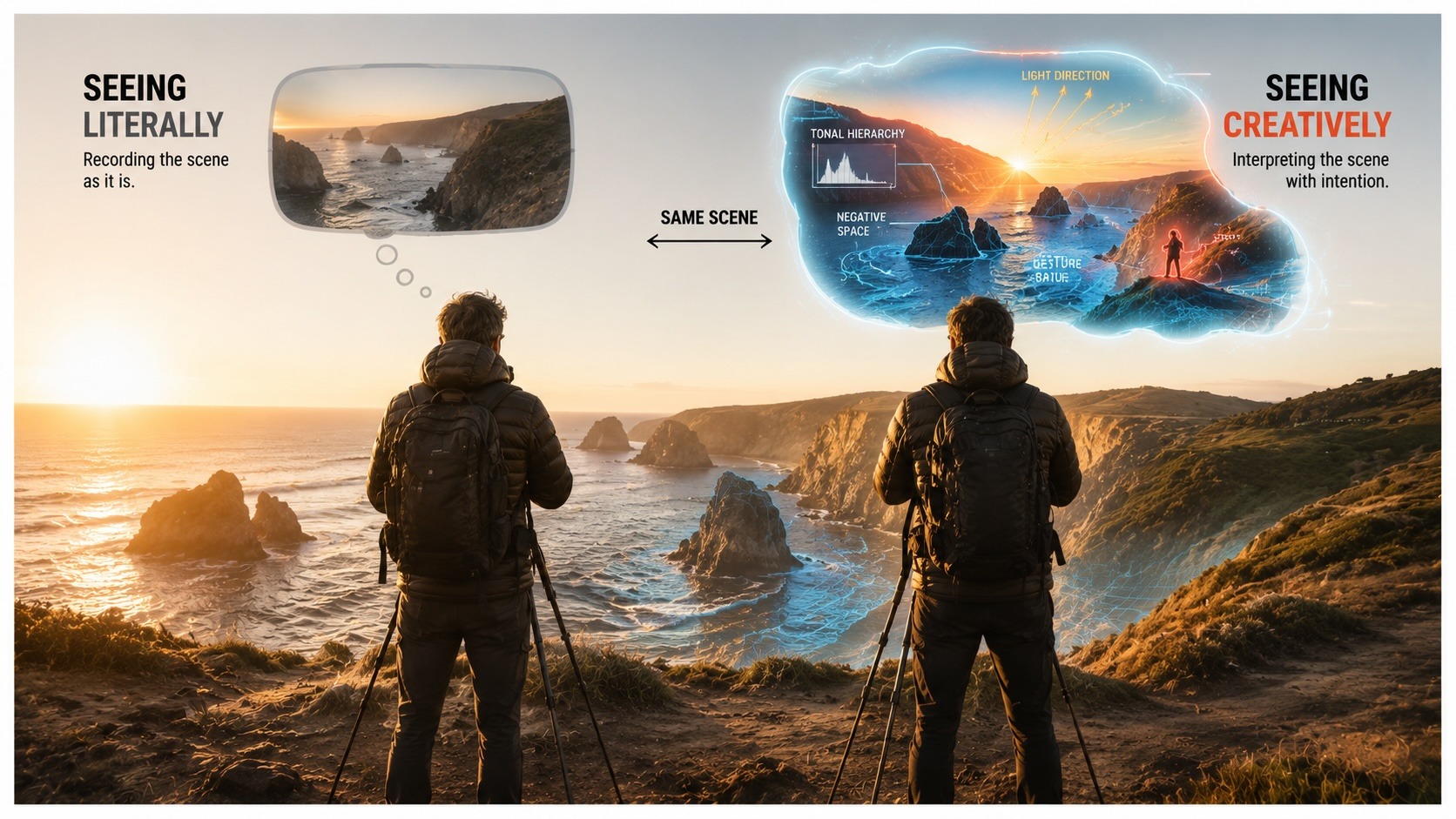
Elevate Your Vision


Read this story and all the best stories on The Luminous Landscape
The author has made this story available to Luminous Landscape members only. Upgrade to get instant access to this story and other benefits available only to members.
Why choose us?
Luminous-Landscape is a membership site. Our website contains over 5300 articles on almost every topic, camera, lens and printer you can imagine. Our membership model is simple, just $2 a month ($24.00 USD a year). This $24 gains you access to a wealth of information including all our past and future video tutorials on such topics as Lightroom, Capture One, Printing, file management and dozens of interviews and travel videos.
- New Articles every few days
- All original content found nowhere else on the web
- No Pop Up Google Sense ads – Our advertisers are photo related
- Download/stream video to any device
- NEW videos monthly
- Top well-known photographer contributors
- Posts from industry leaders
- Speciality Photography Workshops
- Mobile device scalable
- Exclusive video interviews
- Special vendor offers for members
- Hands On Product reviews
- FREE – User Forum. One of the most read user forums on the internet
- Access to our community Buy and Sell pages; for members only.
You may also like