


|
In beauty may I walk; Beautifully will I possess again On the trail marked with pollen may I walk; With beauty before me may I walk In old age, wandering on a trail of beauty, lively; ~Navajo Prayer |
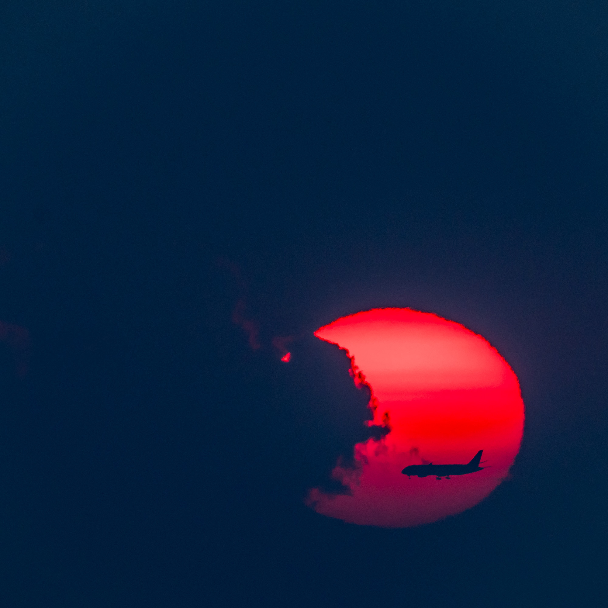
Click on image for more information
Every year they come, from all over the world.
To the American desert they come.
To the land of blue sky they come.
To the land of red sand they come.
To the land of blazing sun they come.
To the Navajoland they come.
To wander all day long they come.
To walk in beauty.
Nearly a million people a year, from all ends of the earth, journey to the area we Americans call Navajoland. They come to see the spectacle of the great American red desert. They come to see the ancient dwellings of the almost mythical Anasazi. They come, mostly to Canyon de Chelly and Monument Valley tribal park. Little do they know that nearby, lies a less traveled path. A path with a beauty and story all its own.
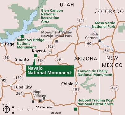
Navajo National Monument sees about 10% of the visitor traffic that the Canyon de Chelly and Monument Valley area get. It is however, in it’s own way, every bit as impressive as the other two famous locations. If you enjoy less people, more adventure and a quantum of solitude in your journey, it just night be the place for you.
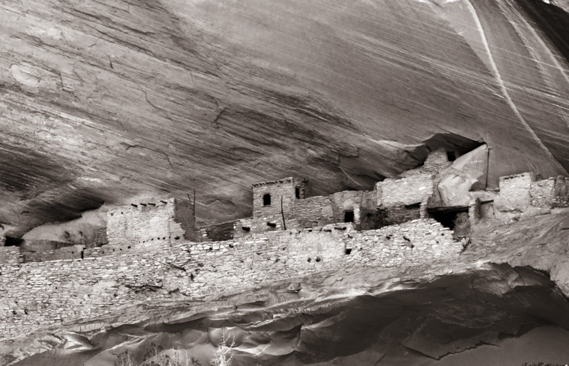
The main attractions of Navajo National Monument are three great Anasazi ruins. They are Betatakin, Inscription House and Keet Seel. Byron Cummings, an archaeologist, and John Wetherill, a local rancher and trader, explored the ruins of Keet Seel, the largest of the sites, in 1907. Two years later Cummings and Wetherill discovered the ruins of Betatakin and Inscription House.
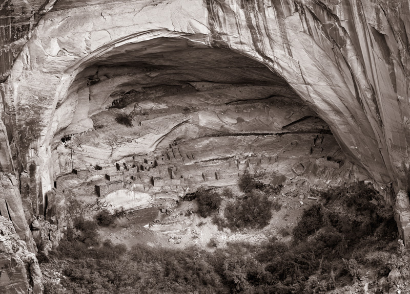
In Navajo,Betatakinmeans “House Built on a Ledge”. Betatakin was built in an enormous alcove measuring 452 feet high and 370 feet across between 1260 and 1290AD. Betatakin was constructed of sandstone, mud mortar, and wood. During its heyday it is estimated Betatkin had a maximum population of about 125 people.
Betatakin is easily photographed from an overlook after a short and easy hike of several hundred yards on the Sandal Trail from the visitor center. In the summer months, from May through September, it is possible to take aranger led hikeand visit the ruins close up. The hike is a moderately strenuous 5-mile round-trip hike and takes 3 to 5 hours using the Tsegi Point Trail. It begins at 7,300 ft. elevation, then loses and regains 700 feet
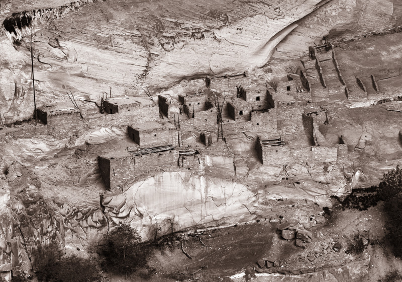
In Navajo,Keet Seelmeans “broken house”. Keet Seel was built in a branch of Tsegi canyon between 1250 and 1286AD. At its peak, it is believed that Keet Seel was inhabited by up to 150 people. Keet Seel is considered by many archaeological experts to be one of the best preserved larger ruins in the American Southwest.
Click on image for more information
Click on image for more information
Unfortunately for the casual visitor, Keet Seel is located over 8 miles from the visitor center. During the warmer months, hikers may choose to day hike or stay overnight in the designated campground near Keet Seel. Keet Seel hikes requires advance reservation and obtaining a back country permit at the visitor center. Daily limit is 20 people for this 17-mile round-trip hike on a primitive trail; elevation loss and regain is 1000 feet. Hike on sand hills and rocks, cross ankle-deep stream many times Click“here”to download current Keet Seel hiking information in a PDF format.
Inscription House is located in Nitsie Canyon, about 8 miles west of the visitor center. It derives its name from an inscription scratched into the clay plaster of a wall. It reads, “Shapeiro Ano Dom 1661.” An intrepid early Spanish explorer or missionary, probably on his way to or from the Colorado River, must have entered the canyon in which this ruin is located and paused at the long-abandoned pueblo to scratch a record of his visit.
Unfortunately for photographers, Inscription House is now closed and off limits to visitors. The reasons are mostly environmental. Erosion in the area has made it “positively dangerous” to reach the dwelling. No plan is in place for stabilizing things and opening the ruins in the near future.
At an altitude of over 7,000 feet, Navajo National Monument is a great deal cooler than the either Canyon de Chelly or Monument Valley. This makes it an attractive location if you plan visit the area during the summer tourist season.
If you wish to learn more about this area and other photographic locations in Navajoland, you might want check out our newNavajoland Photoguide.

About Miles Hecker
Miles has been involved with photography for over forty years. He teaches digital photography at Casper College in Casper, WY. His photos have won awards fromNatures Best magazine,Photo.net, The Luminous LandscapeandWyoming WIldlife . Miles’ photos have been published in American Vignette, Backpacker Magazine, Natures Best Images, Popular Photography, Wyoming Audubon, and Wyoming Wildlife. He is co-founder ofWyofoto LLC
Geotagged Photolocation Index
September 2013


Elevate Your Vision


Read this story and all the best stories on The Luminous Landscape
The author has made this story available to Luminous Landscape members only. Upgrade to get instant access to this story and other benefits available only to members.
Why choose us?
Luminous-Landscape is a membership site. Our website contains over 5300 articles on almost every topic, camera, lens and printer you can imagine. Our membership model is simple, just $2 a month ($24.00 USD a year). This $24 gains you access to a wealth of information including all our past and future video tutorials on such topics as Lightroom, Capture One, Printing, file management and dozens of interviews and travel videos.
- New Articles every few days
- All original content found nowhere else on the web
- No Pop Up Google Sense ads – Our advertisers are photo related
- Download/stream video to any device
- NEW videos monthly
- Top well-known photographer contributors
- Posts from industry leaders
- Speciality Photography Workshops
- Mobile device scalable
- Exclusive video interviews
- Special vendor offers for members
- Hands On Product reviews
- FREE – User Forum. One of the most read user forums on the internet
- Access to our community Buy and Sell pages; for members only.
You may also like