


By: Andrew Masur
In early June 2008 I and two family members had the opportunity to visit the Great Northern Peninsula of Newfoundland for a week of landscape and nature photography. When thinking of Newfoundland the first thought in most people’s minds is that it’s an island and should be quick and easy to get around. One look at a map is all you need to see that this isn’t the case; Newfoundland is deceptively large. With this in mind we decided to focus specifically on a single portion of the island in order to maximize the photographic opportunities, and to ensure that more time was spent behind the camera than behind the wheel.

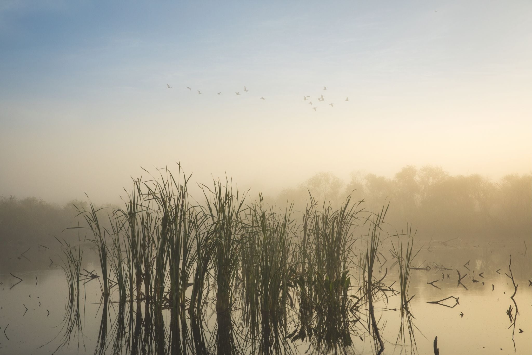
Sunset on the Bay; Gros Morne National Park; June, 2008
Canon 40D with Sigma 10-20 EX @ ISO 100
One area that immediately jumped out, at least for me, was the Great Northern Peninsula. The attraction of greatest interest, and where we spent the majority of the trip, wasGros Morne National Park. This UNESCO world heritage site is quite literally a photographer’s paradise filled with tree and mist covered mountains worn down by the march of time, 400 million year old sea bed pushed up by the Earth’s tectonic forces, kilometres of untouched North Atlantic coastline, quaint fishing villages, and panoramic vistas seemingly around every bend in the road. There will be more detail about the park and its many sights later in this article; however Gros Morne could easily withstand 1-2 weeks of intense shooting.
The second area of interest was theL’Anse Aux Meadowsnational historic site located near the town of St. Anthony at the very tip of the peninsula. This site is the second UNESCO world heritage site on the island and is of great historical significance. The drive to L’Anse Aux Meadows is almost as interesting as the site itself, with a vastly different topography than that found in Gros Morne. With two UNESCO sites (some of the most incredible places on Earth from my experience), and a seemingly endless array of landscapes in between, the Great Northern Peninsula seemed like the perfect location for our first visit to Newfoundland.
______________________________________________________________
Getting There
Travel from within Canada is fairly easy. Living in the Toronto area, I was able to catch a flight from Pearson International directly to the airport in Deer Lake, Newfoundland. During the summer season WestJet has one round-trip flight per day between Toronto and Deer Lake. This is an ideal place to start a trip to this location since the town is located quite close to Gros Morne yet still has numerous car rental locations and other necessities such as fuel and groceries. International travelers will most likely have to fly into St. John’s and then make arrangements with a local air charter to Deer Lake, or rent a car and make the drive themselves.
______________________________________________________________
Getting Around
The Northern Peninsula can be considered quite remote, however this is only relative, it is in Canada after all! There is one main highway, route 430 that runs north/south along the entire length of a peninsula. The pavement is well maintained and it travels as well as any major highway in a city. A second highway, route 431, branches off from highway 430 and is used to reach several of the trails in Gros Morne. While in Gros Morne these highways are quite steep and twisting, however once you pass out of the park the road levels out and runs along the coast.

Shades of Green; Gros Morne National Park; June, 2008
Canon 40D with Canon EF 28-135 IS @ ISO 100
Gas stations are only found in a few of the larger towns such as Deer Lake, Rocky Harbour and St. Anthony, so make sure to gas up before starting any major drives. Gas in Newfoundland also tends to be quite a bit more expensive than many other locations in Canada, so a 4 cylinder vehicle can provide a great savings, assuming it meets your needs. All of the roads in the area are paved so a 4 wheel drive vehicle is unnecessary. There are several car rental agencies in the Deer Lake airport, so finding a vehicle should not be too difficult, however at the time of our trip they didn’t seem to offer any unlimited kilometre plans so extra charges can quickly add up. This may change in the future however, so call ahead.
One final word of warning that is stressed time and time again is that you shouldn’t drive after dark. Newfoundland has one of the densest Moose populations in the world and they tend to walk out into the road after dark. Moose arehugeanimals and hitting one with a car is usually fatal for the driver and passengers. Just as an example, when we returned our car to the rental agency the clerk said that they had rented out 7 cars that week and that 5 of them had returned with damage from Moose hits.
______________________________________________________________
Where to Stay
Neddies Harbour Sunset; Gros Morne National Park; June, 2008
Canon 40D with Sigma 10-20 EX @ ISO 100
There are many options for places to stay both within Gros Morne and along the length of the peninsula. Within the park there are several camp sites, however these are on a first come first served basis and we were told that during the peak season they fill up fairly quickly. There are also a myriad of bed and breakfasts in many of the towns up and down the coast.
Another option, and the one that we chose for most nights, was to rent a cottage for several days. This is a very popular option in the area and most of the major towns have many different cottages available. A cottage has the advantage of multiple bedrooms if you’re traveling with a number of people, and many also include a full kitchen where you can prepare your own meals. This is great way to save money since many of the restaurants in the area can be somewhat expensive. On the other hand seafood is quite reasonable, so by using the kitchen in a cottage you can eat quite well (verywell actually) for less than you would expect. The town of Neddies Harbour offers a number of very reasonably priced cottages through a company called A Perfect Getaway. We stayed in a cottage in Neddies Harbour for the first three nights of the trip and found it an excellent home base for exploring the park.
______________________________________________________________
Equipment
All photographs were taken using my Canon 40D, with a 300D brought along as backup. This was my first major trip with the 40D and I wanted to make sure I had a known backup just in case of any unforeseen glitches. This turned out to be unnecessary; the 40D was reliable, rugged and a revelation in term of speed and battery life compared to my old 300D.
Lenses consisted of the Sigma 10-20 EX, Canon EF 28-135 IS, a Canon EF 70-200 F2.8L and a Canon EF 1.4X II extender. All lenses performed exactly as expected even though they were soaking wet for long stretches of time due to the weather. Usage was fairly evenly split amongst all the lenses with perhaps a slight edge given to the Sigma.
Layers; Gros Morne National Park; June, 2008
Canon 40D with Canon EF 70-200 F2.8L @ ISO 100
Power was provided by three BP-511A batteries. I had brought the charger thinking that with the heavy shooting I was planning to do I’d be charging the batteries every second day. This didn’t turn out to be the case however since the 40D’s miserly use of power meant that I didn’t even go though all the batteries in a week. In fact the 3 rd battery in the bag wasn’t even touched at the end of the trip. For storage I brought an 8GB, 4GB, two 2GB, and a 1GB compact flash card. Due to horrible weather on the last day, I did not use all the storage I brought, however I still returned with over 1800 images, of which 30-40 I consider “keepers” and a smaller subset of this I consider good enough for printing. There were no errors or other anomalies with the performance of the memory cards even though the weather was cold and wet for most of the week.
Camera support was provided by a Manfrotto 055MF4 carbon fibre tripod with a Manfrotto RC-1 ballhead. The tripod was used for about 98% of the shots taken on the trip. I would often walk the trails with the camera and lens attached to the tripod and slung over my shoulder. After a couple of days of pain (a right of passage perhaps?) my shoulders grew accustomed to the load and it was no longer noticeable. The ballhead performed admirably and took the load of every camera and lens combination without unintended movement or sagging, although with longer lenses a more robust head would be required.
______________________________________________________________
Locations
This section will provide short descriptions of some of the locations visited during the trip.
Gros Morne: Berry Brook Falls Trail

Berry Brook Falls; Gros Morne National Park; June, 2008
Canon 40D with Canon EF 70-200 F2.8L @ ISO 100
This is a very easy trail leading up to a nice waterfall at the end. The trail is a loop around 1.5 km long and moves through rich forests over very gentle terrain. The trail also goes over a series of small bogs leading up to the falls and these are covered in well-maintained boardwalk for easy access. The falls themselves are on a number of levels with a long gently sloped section running over rock. There is also a viewing platform from at the upper level of the falls easily reach by climbing a small staircase. Although quite short the trail is very scenic and people wanting to shoot lush forest could easily spend several hours here.
Gros Morne: Tablelands Trail
Tablelands; Gros Morne National Park; June, 2008
Canon 40D with Sigma 10-20 EX @ ISO 100
The Tablelands are one of the highlights of Gros Morne. This area is seabed that was pushed up 400 million years ago when the North American and African tectonic plates collided. The rocks and soil are extremely high in iron and magnesium which leads to their distinctive colour. This also has the effect of making the soil here unsuitable to all but the hardiest plants. The trail itself is a 4 km gently sloping hike that leads into valley that contains a sizeable stream and waterfall during the spring melt. This area is a photographer’s paradise with interesting vistas in seemingly every direction. Many of the alpine plants here flower with delicate blooms that may be of interest to those who enjoy macro photography. One could easily spend an entire day here exploring the rocky slopes and small streams that dot the region. The rocks, mountains and sky also lead to wonderful contrasts in tonalities and shapes.
Gros Morne: Green Gardens Trail
Shadows; Gros Morne National Park; June, 2008
Canon 40D with Sigma 10-20 EX @ ISO 100
The Green Gardens trailhead is only several kilometres down the road from the Tablelands trail. It starts out on what could be described as tundra-like terrain that follows a snaking path up a large hill. At the top of this hill the trail splits with one path leading to a small brook and the other leading into a lush valley that eventually reaches the sea. This is a somewhat more difficult trail with many steep uphill and downhill sections. We were not able to reach the sea due to the approach of violent weather, but were told by hikers that had started earlier in the day that the hike from the top of the hill to the ocean was about 7-8 kilometres and quite difficult however the scenery there was fantastic. This is a very nice area of photography with sweeping vistas in multiple directions from the top of the hill and various different colours and shades due to the wide variety of low growing alpine vegetation that covers the hill side. Once you have completed the trail it’s worth driving a bit farther down the road to reach the town of Trout River. This small fishing town is typically Newfoundland with brightly coloured houses set against the grey of the rocks and the blue of the sea.
Welcoming Door; Trout River; June, 2008
Canon 40D with Canon EF 28-135 IS @ ISO 200
Gros Morne: Lookout Trail
Because we went in early June the park’s most famous trail, Gros Morne Mountain, was not open in order to protect wildlife that lives on the mountain and is still in breeding season at that time. The Gros Morne Mountain trail is supposed to provide some of the best views in the park; however the Lookout Trail is a very close second and is open for the entire park season. This is quite a difficult trail that snakes 2.5 kilometres (according to the sign, it surely felt like more….) up the side of a mountain and requires a good level of fitness on the part of the hiker. The vertical rise on this trail is in excess of 800 meters which provides spectacular views of the Tablelands against the lushness of the park’s forests.
Distant Tables; Gros Morne National Park; June, 2008
Canon 40D with Sigma 10-20 EX @ ISO 100
Photographically the climb is not very interesting, however once you reach the boardwalk at about the 1.5-2 km mark of the trail things become vastly more interesting. There is a lookout at the top of the mountain that provides fairly unobstructed views in most directions and makes the difficulty of the climb well worth it.
Gros Morne: Lobster Cove Head Trail

Rocky Shore; Gros Morne National Park; June, 2008
Canon 40D with Sigma 10-20 EX @ ISO 100
This is a very pleasant trail that starts just at the edge of the town of Rocky Harbour. During low tide you can climb amongst the rocks of the beach and turn back and see the lighthouse at the top of the bluff overlooking the cove. This is a good location for sea photography owing to the interesting rock formations on the beach. On a windy day you can get nice shots of breakers as they come on to the rocks of the beach and of seagulls as they ride the air currents just above the waves.
Gros Morne: Broom Point Trail
This is an old fishing settlement that has been restored to much of its original condition. With the old jellybean houses placed right against the cold of the North Atlantic, this location has a lot of atmosphere that practically screams Newfoundland.
Gros Morne: Western Brook Pond

Boardwalk; Gros Morne National Park; June, 2008
Canon 40D with Sigma 10-20 EX @ ISO 100
Along with the Tablelands and Gros Morne Mountain, Western Brook Pond is one of the highlights of the Park. This is an old fjord that has become landlocked and turned into a very large and deep freshwater lake. The hike up to the shore of the lake is very pleasant, consisting of long stretches of boardwalk over bogs interspersed with ridges of spruce forest. There are many small ponds interspersed throughout the bogs and all of them are coloured like tea due to the large amounts of peat in the ground.
Upon reaching Western Brook Pond you can take a 2-3 hour boat tour of the lake. This is highly recommended since the cliffs on either side of the lake are over 900 meters high and provide many spectacular vistas and interesting studies in texture and tonality. If you come early in the season the winter melt dots the area with a myriad of waterfalls from all directions, each seemingly more beautiful than the last. The highlight of these waterfalls is known as Pissing Mare Falls, located at the far end of the lake. The sheer height of this waterfall causes the water to be reduced to a fine mist long before it hits the bottom causing it to cascade down the entire face of the cliff. Of all of the trails in Gros Morne Western Brook Pond is one that you should not miss under any circumstances.

Misty Falls; Gros Morne National Park; June, 2008
Canon 40D with Canon EF 28-135 IS @ ISO 160
Gros Morne: Bakers Brook Falls
This is a moderate trail that basically follows a straight line for 5 km to reach a series of three waterfalls. Apart from the length in each direction the trail is not especially difficult, making extensive use of boardwalk. Much of the terrain leading up to the falls is very strange with trees all toppled in the same direction as if the area has been blasted by a meteorite.

Falling Water; Gros Morne National Park; June, 2008
Canon 40D with Canon EF 70-200 F2.8 @ ISO 100
The falls themselves are very nice with multiple cascades and several viewing platforms. The water within the brook is not very deep so it’s quite easy to set up a tripod directly in the water for more unique angles and to use a telephoto to pick out details.
Highway 430
The drive along highway 430 to St. Anthony is quite pleasant and provides many opportunities for photography. The route is dotted with small fishing villages, many of which time seems to have forgotten. Most contain brightly coloured buildings, fishing gear by the side of the ocean, and people on fishing boats plying their trade.
At Work; Highway 430, Newfoundland; June, 2008
Canon 40D with Sigma 10-20 EX @ ISO 100
One spot of particular interest here is Port Aux Choix. This fairly large fishing town has been under continuous habitation for over 5000 years. It contains a national historic site and several archaeological sites that you can visit. The historic site contains a number of trails that provide some nice photographic opportunities of limestone cliffs jutting out into the ocean. There is also an abundance of multicoloured alpine plants that can make for some interesting compositions against the stark grey of the limestone.
St. Anthony
Deep Thoughts; St. Anthony, Newfoundland; June, 2008
Canon 40D with Sigma 10-20 EX @ ISO 100
The town of St. Anthony is the northernmost settlement on the Great Peninsula. Photographically there are a few areas of interest. The first of these is Fisherman’s Point which is literally a huge chunk of rock thrust out into the ocean. The point has numerous trails and a number of very rocky beaches to explore, although during windy weather this can be somewhat hazardous. The whole area is very dramatic with dark cliffs thrusting out into dark and angry ocean. Trees are non-existent by this point with only windswept grasses and creeping alpine plants to add colour to the scene. Also be aware that due to the very northerly latitude the temperatures here are cold well into the summer months. During the first week of June it was only 4 degrees Celsius outside and very windy, so winter clothing was a must.
St. Anthony’s other photographic opportunity of note is iceberg and whale watching. The prominent charter in the area, Northland Discovery Boat Tours, run iceberg and whale watching trips daily starting from the first week in June. Iceberg spotting is best done very early in the season while whales tend to appear closer to the end of June. The tour runs around 2-3 hours and is well worth the cost for the photographic opportunities that it provides.
A Whale of a Tail; St. Anthony, Newfoundland; June, 2008
Canon 40D with Canon EF 70-200 F2.8 @ ISO 250
L’Anse Aux Meadows
The second UNESCO heritage site in Newfoundland is L’Anse Aux Meadows, the site of the first European settlement in North America. The site was settled by the Vikings around 1000 AD as they pushed westward from Greenland. Although the settlement was initially successful, difficulties in communicating with the population of Native Americans in the area lead to misunderstanding and distrust. This soon led to open warfare between the two sides and the Vikings abandoned the site after several seasons, never to return. The site currently has a visitor’s center with a theatre and small museum, the archaeological site itself and a reconstructed Viking settlement. One interesting fact that was presented in the visitor’s center is that L’Anse Aux Meadows is the site where humanity reconnected with itself. When the first tribes of humanity left Africa one group went east and the other went west. The two groups continued to migrate independently and those who went west settled Europe while those who went east would eventually settle in North America as the Native Americans. When the Vikings settled at L’Anse Aux Meadows it was literally the reunion of humanity with the tribes who went east finally rejoining the tribes that went west.
August, 2008
______________________________________________________________
Andrew Masuris a space systems engineer working in Brampton, Ontario. When he’s not busy building hardware for the Space Shuttle, he can be found shooting photos of things more down to Earth.

Elevate Your Vision


Read this story and all the best stories on The Luminous Landscape
The author has made this story available to Luminous Landscape members only. Upgrade to get instant access to this story and other benefits available only to members.
Why choose us?
Luminous-Landscape is a membership site. Our website contains over 5300 articles on almost every topic, camera, lens and printer you can imagine. Our membership model is simple, just $2 a month ($24.00 USD a year). This $24 gains you access to a wealth of information including all our past and future video tutorials on such topics as Lightroom, Capture One, Printing, file management and dozens of interviews and travel videos.
- New Articles every few days
- All original content found nowhere else on the web
- No Pop Up Google Sense ads – Our advertisers are photo related
- Download/stream video to any device
- NEW videos monthly
- Top well-known photographer contributors
- Posts from industry leaders
- Speciality Photography Workshops
- Mobile device scalable
- Exclusive video interviews
- Special vendor offers for members
- Hands On Product reviews
- FREE – User Forum. One of the most read user forums on the internet
- Access to our community Buy and Sell pages; for members only.
You may also like