


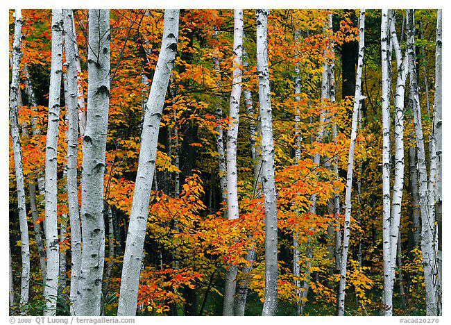
Birch trunks and red maple leaves. Canham KBC 5×7, Fuji Velvia, Fuji C 450mm, f/64 2s
Waiting for pictures
Acadia National Park packs a great variety of scenery in a small (only 40,000 acres, 5th smallest US National Park) and easily accessible area . The shoreline includes beaches, headlands, boulders, and slabs with a range of orientations. Large and small freshwater bodies are surrounded by two major forest types (eastern deciduous and coniferous north woods) meet. Capping them is the highest point on the east coast of the Americas from the Arctic to Rio de Janeiro.
When to go
Spring is quiet, with the benefit of wildflowers and budding trees. Summer visitation can be overwhelming, as the park receives 2 million visitors in the year – it is the only National Park in New England, within a day’s drive for more than 50 million people. However, most equate with Acadia National Park with the east side of Mount Desert Island. There is plenty of quiet to be found on the west side and the two other units, the Schoodic Peninsula and Isle Au Haut.
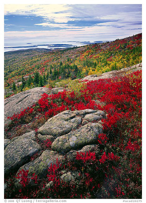
Autumn arrives in October, and in general peaks in the middle of the month. This is the best time to be there, as exquisite color is present through the park, not only on the trees, but also on the ground, thanks to the berry plants characteristic of northern locales. Winter closes most park roads.
The Classics
Cadillac Mountain
Cadillac Mountain, the grandest of the peaks in the park, is also the most accessible, as a road leads to the top. The trees growing on the summit, stunted and twisted like bonsai, will not hamper your views over water and forests in all directions. I like to set a foreground to those extensive views using berry plants and lichen-covered granite slabs. In the fog, those make interesting subjects on their own. Because of its eastern position and elevation, the first sun rays to strike the continent are seen from Cadillac Mountain, so it is a great sunrise location – popular with non-photographers as well. I was surprised to see the parking lot half full at 5.30am, and visitors spreading out with blankets on the rocks. They stay close to the lot, so for more varied views and less people, you can hike a short trail around the summit. Sunset is also good, but then the light on the summit road is better than on the summit itself.
Early morning autumn from Cadillac Mountain.
Canham KBC 5×7, Fuji Velvia, Schneider Super Angulon 120mm, 2-fstop GND, polarizer, f/22 1/2s
Ocean Drive
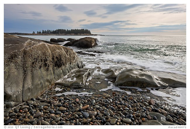
Between Sand Beach and Otter Point, a road and a trail follow for two miles one of the most scenic coastlines in Maine. Spots where you can express the power of the ocean shaping the land include many pink granite ledges, and a coble beach with large rounded stones close to Otter Point. If the conditions are right, Thunder Hole can provide spectacular wave action. Because of the Southeast orientation, I much prefer sunrise there. The road is one-way so you cannot backtrack, and the number of pull-outs is limited, therefore I advice to scout out locations the day before. Other favorite coastal locations include Great Head, Sand Beach, Hunter Cover and Bass Harbor Light.
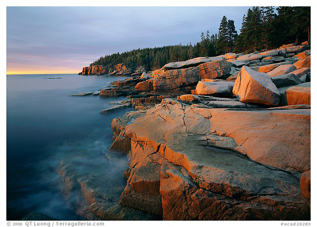
Granite slabs and Otter Point headland at sunrise.
Canham KBC 5×7, Fuji Velvia, Schneider Super Angulon 120mm, polarizer, f/22 1/4s
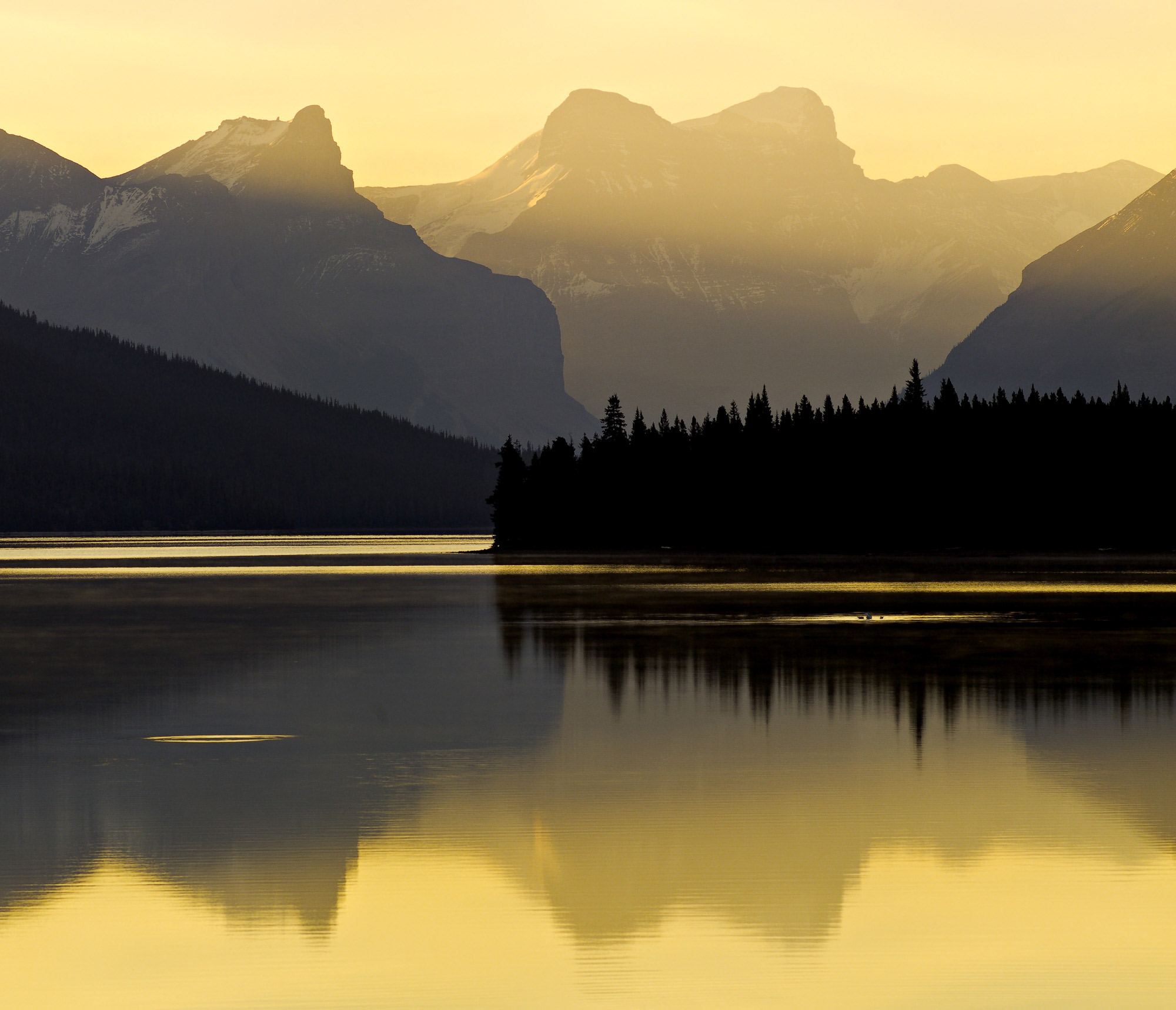
Jordan Pond
This lake is surrounded by steep forested hills which turn a kaleidoscope of colors in autumn. I like to hike the trails around the lake to take in the intimate beauty of the woodlands, especially on overcast or foggy days. Any time of the day can work there, but dawn and dusk are particularly good for reflections on the calm surface. A short stroll from the Tea House, the south shore offers many possibilities, with the distinctive shape of the two Bubbles in the distance balanced by boulders in the lake. For less classical views, you can hike the three-mile trail around the lake or check the view of Jordan Pond from the top of the Bubbles, reached by a short but steep trail. Other favorite lakes include Eagle Lake, Bubble Pond, and Echo Lake (on the West side).
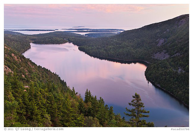
Jordan Pond from the Bubbles at sunset.
Canon EOS 5D Mark II, 24-105 @ 47mm, f/9.0 2.5s ISO 100
Out Of The Beaten Path
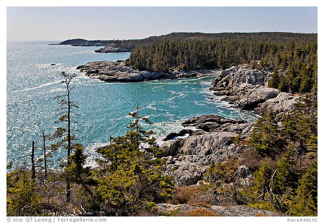
The Schoodic Peninsula.
The Schoodic Peninsula is the only part of the Park on the mainland. I found it a bit reminiscent of Ocean Drive, with a one-way loop road hugging the shoreline. The lack of a tall headland is made up by the variety of orientations, permitting nice sunsets as well as sunrises, and the presence of off-shore, tree-covered, islets. Besides granite slabs, the flatter terrain hosts also extensive tide pools and beaches. In particular, there is an interesting cobble barrier beach close to the tip. Visitation is very light, which is a welcome change from the main Park Loop on Mount Desert Island.
Mid morning, Schoodic Peninsula.
Canon EOS-1Ds Mark III, 24TSE, f/22.0 1/8s ISO 100
Isle au Haut
Although Acadia is one of the 10 most visited National Parks, the adventurous can still experience a truly remote place with a feeling of wilderness at Isle au Haut. There is a quota of 50 visitors allowed on the island per day. Besides protecting this fragile environment, the quota helps preserve the feeling of isolation which makes a visit to Isle Au Haut so special. During a mid-march day there and a 15-mile hike there, I did not see any single other person.
Isle au Haut, can be reached by a 45 min mail boat crossing from Stonington (for the complete schedule, see http://www.isleauhaut.com/). There is a general store in the village, however it opens only for a couple of hours on a couple of days each week so you’d better bring everything you need. Although some of the island residents own vehicles, they are not available to visitors, so once you land on the island, you need to move either on foot or bicycle. A mountain bike could be useful for getting around (a dirt road circles the island) but it would need to be brought from the mainland. I was hoping for good views from Bowditch Mountain, as mentioned in a guidebook, however after the steep hike, I was disappointed to find the top overgrown. The Goat Trail, scrambling over bare rock outcrops, is the most scenic part of the island I’ve seen, thanks to the shoreline inlets, coves, and higher viewpoints. Early morning light would be spectacular. A NPS campground is located at Duck Harbor, about 2 miles from there, and in summer the mail boat stops there.
Coastline seen from Goat Trail, mid-day, Isle Au Haut.
Canon EOS-1Ds Mark III, 24-105 @ 28mm f/8.0 1/100s ISO 100
See more Images of Acadia National Park
QT Luong is a full-time photographer from California, known for being the first to photograph all 59 US National Parks – in Large Format. Ken Burns featured him in “The National Parks: America’s Best Idea” (2009). His photographs, published in dozens of countries around the world, have been the subject of the two large-format books “Beautiful North America” and “Spectacular Yosemite”, several magazine profiles, solo gallery and museum exhibits. He offers a limited number of photo tours and workshops designed to be incredible adventures as well.
Updated: March 8, 2015

Elevate Your Vision


Read this story and all the best stories on The Luminous Landscape
The author has made this story available to Luminous Landscape members only. Upgrade to get instant access to this story and other benefits available only to members.
Why choose us?
Luminous-Landscape is a membership site. Our website contains over 5300 articles on almost every topic, camera, lens and printer you can imagine. Our membership model is simple, just $2 a month ($24.00 USD a year). This $24 gains you access to a wealth of information including all our past and future video tutorials on such topics as Lightroom, Capture One, Printing, file management and dozens of interviews and travel videos.
- New Articles every few days
- All original content found nowhere else on the web
- No Pop Up Google Sense ads – Our advertisers are photo related
- Download/stream video to any device
- NEW videos monthly
- Top well-known photographer contributors
- Posts from industry leaders
- Speciality Photography Workshops
- Mobile device scalable
- Exclusive video interviews
- Special vendor offers for members
- Hands On Product reviews
- FREE – User Forum. One of the most read user forums on the internet
- Access to our community Buy and Sell pages; for members only.
You may also like