


| I shall be telling this with a sigh Somewhere ages and ages hence:
Two roads diverged in a wood, and I– took the one less traveled by, And that has made all the difference. ~Robert Frost |
Most visitors to the Moab area of Utah come to see the well known Arches National Park. Approximately one million people annually pass through it’s gates. About half that number spend another day and experience the nearby Islands in the Sky Area of Canyonlands National Park. Both of these offer a wonderful southwestern desert experience with the main attractions being within several hundred yards of a parking area.
About an hours drive to the south of Moab lies another part of Canyonlands. It is not as well known as it’s northern brethren. It hides it secrets from those unwilling to journey far from their car. It is in the true sense of Robert Frost’s lines, the road less traveled.
Click on image for more information
Click on image for more information
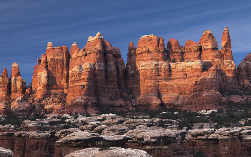
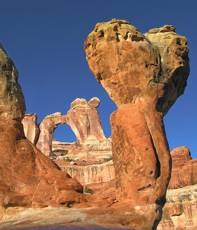
Located about 40 miles south of Moab, The Needles District of Canyonlands forms the southeast corner of the park and was named for the colorful spires of Cedar Mesa Sandstone that dominate the area. It is an area for hiking and 4 wheel driving. Very little of the area is accessible from a paved road.
The district’s extensive trail system provides many opportunities for long day hikes and overnight trips. Foot trails and four-wheel-drive roads lead to such features as Tower Ruin, Confluence Overlook, Elephant Hill, the Joint Trail, and Chesler Park.
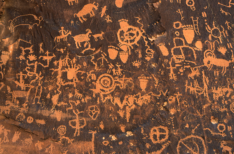
In fact, the only attraction that is easily driven to is located outside the park. Newspaper Rock is actually located 19 miles SE of the Needles district of Canyonlands NP on highway 211 . Newspaper rock is a part of a “desert varnished” vertical Wingate sandstone cliff that encloses the upper end of Indian Creek Canyon, and is covered by hundreds of ancient Indianpetroglyphs. In Navajo, the rock is called “Tse’ Hane'” which translates to a rock that tells a story. The petroglyphs at this site have been dated back as far as 2,000 years
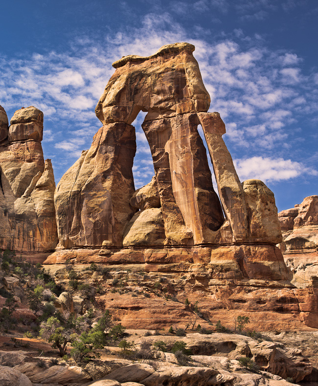
My favorite feature in the area is Druid Arch. Druid Arch is a very dramatic feature sitting in an elevated bowl near the end of Elephant Canyon. The arch has a height of 85 feet and a span of 20 feet. It is very reminiscent of the prehistoric monuments located in the English county ofWiltshire.
If you plan your hiking trip well, you can photograph The Needles and Druid Arch on the same 12 mile round trip excursion. In mid March we left the Squaw Flat trail head about an hour before sunrise. After stopping briefly to photograph The Needles at sunrise, we headed on to Druid Arch. Located near the head of Elephant Canyon, about 6 miles from the trail head, Druid Arch is quite impressive. If will take about 2-3 hours travel time for a typical hiker to reach the arch. It will take about the same time on your return trip to the parking lot.
Day hikes to the arch do not require a permit, but be aware that water on the trail is scarce, so be sure to carry plenty. Also, avoid making the hike in the summer. It can be very hot in the desert in the afternoon, especially from May through September.
Click on image for more information
Click on image for more information
If you truly are adventurous, consider an overnight backpacking trip to see and photograph Angel Arch. Angel Arch is located in the remote Salt Creek Canyon area of the Needles District and is the largest arch in Canyonlands. It is 100 feet wide and 150 feet tall.
This wonderful Arch is about 10 miles from the nearest trail head, Angel Arch is one of the most remote arches in all of Canyonlands. It might be possible to see it on a marathon 20 mile day hike, but the harsh mid day light would not do the arch justice photographically speaking. Instead, plan an overnight camping trip if you wish to get a good photo of this site. Information on backpacking in the Needles may be found atthis link.
The most famous and classic photo of Angel Arch, puts another sandstone feature known as “The Molar” in the foreground.
To plan your photo trip to this area of Canyonlands and learn more about the Moab area in general, check out our free online Arches NP photomap and it’s companion Moab area photoguidehere.

About Miles Hecker
Miles has been involved with photography for over forty years. He teaches digital photography at Casper College in Casper, WY. His photos have won awards fromNatures Best magazine,Photo.net, The Luminous LandscapeandWyoming WIldlife . Miles’ photos have been published in American Vignette, Backpacker Magazine, Natures Best Images, Popular Photography, Wyoming Audubon, and Wyoming Wildlife. He is co-founder ofWyofoto LLC
Geotagged Photolocation Index
October 2012


Elevate Your Vision


Read this story and all the best stories on The Luminous Landscape
The author has made this story available to Luminous Landscape members only. Upgrade to get instant access to this story and other benefits available only to members.
Why choose us?
Luminous-Landscape is a membership site. Our website contains over 5300 articles on almost every topic, camera, lens and printer you can imagine. Our membership model is simple, just $2 a month ($24.00 USD a year). This $24 gains you access to a wealth of information including all our past and future video tutorials on such topics as Lightroom, Capture One, Printing, file management and dozens of interviews and travel videos.
- New Articles every few days
- All original content found nowhere else on the web
- No Pop Up Google Sense ads – Our advertisers are photo related
- Download/stream video to any device
- NEW videos monthly
- Top well-known photographer contributors
- Posts from industry leaders
- Speciality Photography Workshops
- Mobile device scalable
- Exclusive video interviews
- Special vendor offers for members
- Hands On Product reviews
- FREE – User Forum. One of the most read user forums on the internet
- Access to our community Buy and Sell pages; for members only.
You may also like